Projects
Current Projects:
Carbon Sequestration in Seagrass Meadows across the Chesapeake Bay Salinity Gradient
With support from NASA, our research team is exploring the biogeochemical cycling processes associated with carbon sequestration in seagrass meadows. We are using satellite remote sensing tools to understand spatial and temporal variability in above-ground biomass, and data from sediment cores to measure below-ground organic carbon storage. We observe that freshwater meadows tend to store considerably more organic material in the below ground, while saline meadows (and the abundance of sulfate) are converting that organic material to bicarbonate , through a process known as the shallow water alkalinity pump.
Marsh restoration strategies in the lower Chesapeake Bay
Our team is working on a variety of marsh-restoration projects in Norfolk and the surrounding area, with the aim of developing a holistic understanding of restoration “success.” Specifically, we are studying “Living Shorelines,” which are an engineering solution that are constructed to emulate marsh appearance and function, while providing wave attenuation and shoreline stabilization. We are particularly interested in understanding the ecosystem function (including carbon, nutrient, and pollutant sequestration) provided by natural marsh peats that may be absent in the clean sands used for marsh restoration.
We are also in the early stages of site characterization for future restoration by a process known as “thin-layer placement,” where locally sourced dredge material is applied to the marsh to gain elevation in the absence of natural sediment supply. Our team is characterizing the existing vegetation, sediment, and hydrodynamic conditions to inform future restoration projects.
Hydrodynamics of the lower James River , VA:
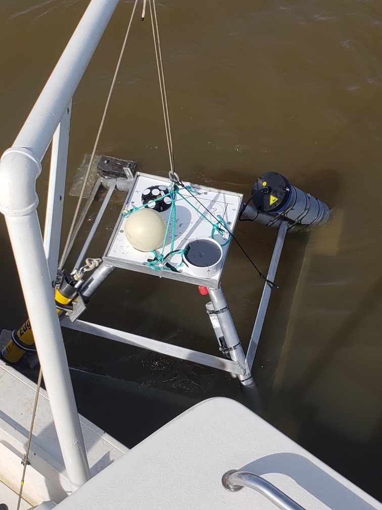
In support of the Hampton Roads Sanitation District, we are monitoring water velocity, salinity, and suspended sediment concentration at a location in the lower James River. During much of the year, we expect this location to exhibit classic shallow-estuary characteristics like reversal of current orientation on tidal time scales, a horizontally stratified water column, and potentially the presence of an estuarine turbidity maximum (ETM). During floods of the James, however, we expect this system to behave like a tidal river. Water will be full fresh, and discharge will be modulated by the stage of both the tide and river, but only flowing towards the lower Chesapeake (i.e., not reversing). We expect that these changing conditions will impact the sediment being deposited and stored in this region, which we will examine by collecting grab sample on cores periodically throughout the year.
This research was funded by the Hampton Roads Sanitation District.
Reference
Hale, R.P., Brown, K.F., and McGill, S. Sediment Dynamics of the Lower James River, VA. Southeast GSA Meeting, Charleston SC. March 2019.
Former Projects:
Shallow-water bathymetry using SAR – Eastern Shore, VA:
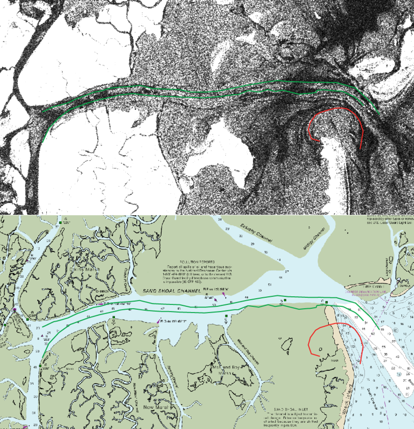
Measuring the bathymetry of shallow coastal environments presents a variety of challenges. Traditional ship-based methods lack spatial coverage and temporal frequency, while previous attempts at remote sensing are either infrequent, inaccurate, prohibitively expensive, or all of the above. Satellite-based synthetic aperture radar (SAR) presents the potential to overcome many of these challenges, by capitalizing on data that are already being collected in shallow coastal regions. SAR measures surface roughness, which in shallow coastal environments appears to be strongly controlled by the underlying bathymetry. In this project, we will directly measure the hydrodynamics and bathymetry of Sand Shoal Inlet on Virginia’s Eastern Shore during a predicted flyover by the European Space Agency’s Sentinel 1A satellite, which will be capturing a SAR image. We can then use the relationships between water depth, hydrodynamic conditions, and surface roughness, to convert SAR backscatter to shallow-water bathymetry.
This research is funded by the Virginia Space Grant Consortium New Investigator Program.
Reference:
Hale, R.P., Lucio, J., and Brown, K.F. Determining bathymetric change in a tidal inlet using satellite-based synthetic aperture radar. Submitted abstract for 2018 AGU Fall Meeting, Washington, DC. December 2018.
Linking harmful algal blooms with sediment resuspension – Lafayette River, Norfolk, VA:
The Lafayette is a conveniently located micro tidal estuary, which is part of the Elizabeth River. Although the Lafayette is one of the most-restored systems on the Chesapeake Bay, harmful algal blooms (HAB) remain a frequent occurrence during summer months. Previous research in the Lafayette suggests that resuspension of nutrient-rich sediments, rather than precipitation-induced runoff, is responsible for initiating some of these HAB. In collaboration with the Mulholland Lab at ODU, we are investigating the cause, frequency, and intensity of sediment resuspension events, and the potential roll of these events in sparking HAB.
References (* denotes student author):
*McGill, S., and Hale, R.P. An Investigation of Sediment Resuspension’s Role in the Proliferation of Harmful Algal Blooms. Southeast GSA Meeting, Charleston SC. March 2019.
*McGill, S., Hale, R.P., and Mulholland, M. Sediment resuspension and its possible link to harmful algal blooms in a shallow micro-tidal estuary. Submitted abstract for 2018 AGU Fall Meeting, Washington, DC. December 2018.
*Weaver, H., Hale, R.P. Determining the causes and threshold of sediment resuspension in the Lafayette River. Southeast GSA Meeting, Knoxville, TN. April, 2018.
Sediment transport and deposition in a human-modified landscape – Bangladesh:

We are currently studying sediment processes on the Ganges-Brahmaputra delta in Bangladesh. Specifically, we are interested in the forces controlling sediment transport and deposition at time scales ranging from individual tidal cycles, to seasons, to years. The broader goal of this project is to develop management solutions for local communities facing dire and immediate consequences associated with land-use change and sea-level rise.
We have been developing a sediment budget for one particularly hard-hit area that spans time scales ranging from individual tides to spring-neap cycles, to monsoon-dry season variability. Understanding how much sediment is in the system, and what this sediment is made of, are important factors to consider for any potential remediation effort. In addition, we are studying sedimentation in the Sundarbans National Forest, which is relatively undisturbed by human activity. Ideally, we can apply this understanding of processes occurring in the natural environment to inform decisions in the human-modified areas.
This research is or has been funded by: the World Bank, the Office of Naval Research (N00014-11-1-0683), the National Science Foundation (Coastal SEES – #1600319), CRDF-Global, and the PADI Foundation.
References (* denotes student author):
*Bain, R.L., Hale, R.P., and Goodbred, S.L, 2019. Flow reorganization in an anthropogenically modified tidal channel network: an example from the southwestern Ganges-Brahmaputra-Meghna Delta. JGR-Earth Surface.
*Brown, K.F., Hale, R.P., Datta, D.K., and Datta, S. Persistence of Depositional Features in a Strongly Seasonal, Tide-Dominated Delta. 2018 AGU Fall Meeting, Washington, DC. December 2018.
Hale, R.P., Bain, R.A., Goodbred, S.L., Best, J.L., 2019.Observations and scaling of tidal mass transport across the lower Ganges-Brahmaputra delta plain: implications for delta management and sustainability. Earth Surface Dynamics. https://doi.org/10.5194/esurf-2018-66.
Hale, R.P., Wilson, C.A., Bomer, E.J., 2019. Seasonal variability of forces controlling sedimentation in the Sundarbans National Forest, Bangladesh. Frontiers in Earth Science. DOI: 10.3389/feart.2019.00211
*Bomer, E.J., Wilson, C.A., and Hale, R.P., in review 2019. Surface elevation and sedimentation dynamics in the Ganges-Brahmaputra tidal delta plain, Bangladesh: implications for the sustainability of natural and human-impacted coastal systems. Frontiers in Earth Science.
Wilson, C.A., Goodbred, S.L., Small, C., Sams, S., Mallick, B., Hale, R.P., 2017. Widespread infilling of tidal channels and navigable waterwaus in human-modified tidal deltaplain of southwest Bangladesh. Elementa.
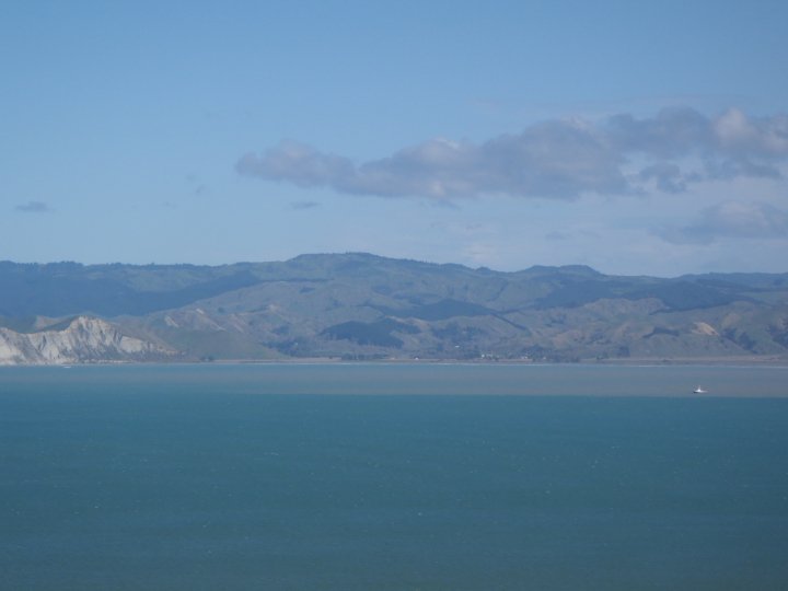
Sedimentary processes of the Waipaoa Margin, New Zealand:
For my Ph.D. research, I investigated sedimentary processes on the continental shelf east of a small, mountainous river on the east coast of the North Island of New Zealand. I deployed instrument packages in three locations on the Waipaoa continental margin for one year, with the aim of monitoring sediment transport and deposition. The instruments required servicing in 4-month intervals, at which point seabed sediment cores were collected. My research has identified that waves are the dominant process by which sediment is moved offshore in this system, either when generating WSFM or when resuspending material at lower concentrations, to then be advected offshore by currents. Based on this system’s relatively short reach, the expectation was for strong river-ocean coherence, however I have shown that this is not the case; at least not in the same way coherence is observed in other systems. The presence of a receiving bay for sediment inserts a time-lag for offshelf transport that is not observed in other similarly sized systems. These observational results agree well with the radiochemical and
geochemical signatures observed in sediment cores, as well as the results of the numerical model from this system. Through my research, I have also undertaken the arduous task of calibrating acoustic instruments for use in fine-grained environments, which has been scarcely published previously. This calibrated dataset has allowed me to empirically test a theoretical model of gravity-driven flow in WSFM. These observations also provide first-hand evidence of an idealized WSFM deposit, as described by Macquaker et al. (2010). I have developed a new method for semi-quantitative sediment x-ray analysis, and have used ArcGIS to map my results and interpolate between my discrete coring locations, to understand spatial patterns of seasonal and decadal accumulation.
This research was funded by the National Science Foundation (MARGINS Source-to-Sink OCE0840887, the New Zealand Foundation for Research, Science, and Technology contract CO1 x 0702, and the Marine Physical Resources program within NIWA’s Coasts and Ocean Centre.
References:
Hale, R.P., Ogston, A.S., Nittrouer, C.A., Walsh, J.P., Orpin, A.R., in prep. A method for using digital x-radiography to analytically understand spatial patterns of sediment accumulation history.
Hale, R.P., Ogston, A.S., 2015. In-situ observations of wave-supported fluid-mud generation and deposition on the continental shelf. JGR Earth Surface 120, doi:10.1002/ 2015JF003630.
Kuehl, S.A., Alexander, C.R., Blair, N.E., Harris, C.K., Marsaglia, K.M., Ogston, A.S., Orpin, A.R.,…Hale, R.P.,… 2015. A source to sink perspective of the Waipaoa River margin. Earth-Science Reviews DOI: 10.1016/j.earscirev.2015.10.001.
Hale, R.P., Ogston, A.S., Walsh, J.P., Orpin, A.R., 2014. Sediment transport and deposition on the Waipaoa River shelf, New Zealand. Continental Shelf Research 86: 52-65.
Walsh, J.P., Corbett, D.R., Kiker, J., Orpin, A.R., Hale, R.P., Ogston, A.S., 2014. Short-term evolution of event deposits on the Waipaoa River margin, New Zealand. Continental Shelf Research 86: 85-102.
Sediment gravity flows in a submarine canyon, SW Taiwan:

As part of my M.Sc., I collected and analyzed cores from within a submarine canyon off the southwest coast of Taiwan. Cores were collected prior to, and following, Typhoon Morakot, which struck Taiwan in the summer of 2009. The canyon in this study, Fangliao Canyon, is not fed by a river in modern times, and the goal of the project was to determine what, if any, would be the signature of a major event (e.g., typhoon or earthquake) in a canyon with no direct sediment source. Cores were analyzed for sediment grain size, sedimentary structures, radioisotopic signatures, and geochemical properties. Through these analyses, I was able to confirm the presence of a flood deposit within the canyon consisting of recently eroded terrestrial sediment, that arrived in the canyon via a gravity-driven flow. While the specifics of the flow could not be confirmed, I suspect that a combination of a sediment-laden river plume and sediment resuspended by wave activity were both responsible for the generation of this hyperpycnal flow.
This research was funded by the National Science Foundation and the National Science Council of Taiwan (NSF-EAPSI 0914272).
Reference:
Hale, R.P., Nittrouer, C.A., Liu, J.T., Ogston, A.O., 2012. Effects of a major typhoon on sediment accumulation in Fangliao Submarine Canyon, SW Taiwan. Marine Geology 326-328, 116-130.
Recent Comments