
Research
Snapshots of a few recent and ongoing research projects:
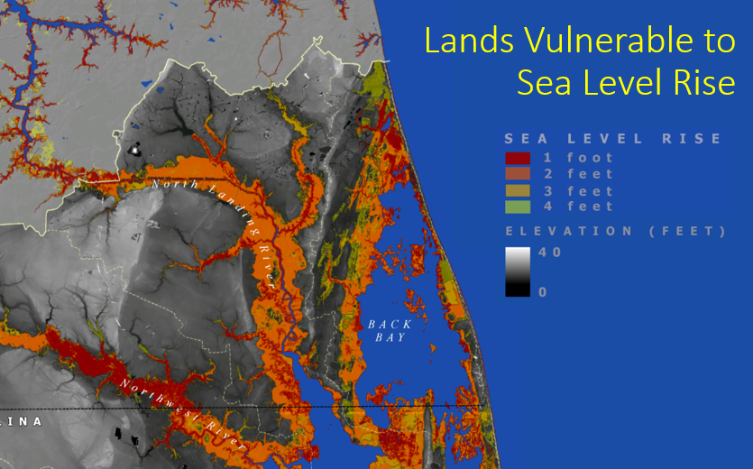
Developing a Coastal Digital Twin using Satellites, GIS, Sensor Networks, and Flood Modeling
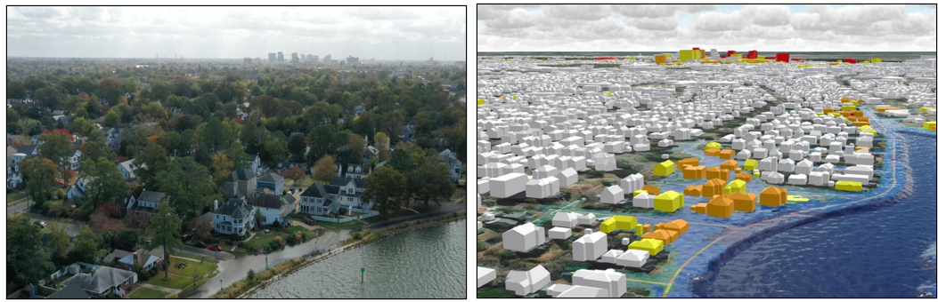
Developing GIS, UAS, and modeling to replicate and then “digitally twin” a coastal environment will allow advances in prediction, planning, and coastal sustainability (Norfolk, Virginia.)
![]()
This NASA-supported project aims to digitally link real-time water and flood sensors, flood models, satellite and drone earth observations, and GIS databases and models to analyze and respond to coastal flooding. This work is in the early stages assimilating data, connecting IoT flood sensors, modeling flooding and sea level rise and building algorithms to predict impacts and assess vulnerabilities. An emphasis on environmental and climate justice perspective focuses on spatial disparities of public health and exposure to flooding in Hampton Roads. The effort seeks to develop a prototype digital twin to address these emerging coastal hazards and public health disparities with emphasis on flooding from storms and sea-level rise and engage emergency managers and resilience planners. You can visit our Pixels Coastal Resilience Hub Site for more information.
National Parks and Rural Coastal Adaptation
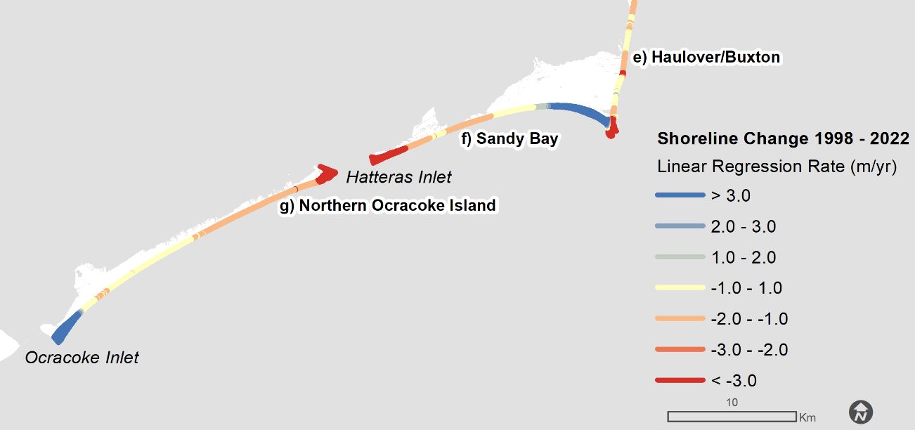
Example shoreline change rates along southern Hatteras I. and Ocracoke I.
Working with the Cape Hatteras National Seashore, US National Park Service, colleagues and I from ECU undertook a vulnerability assessment of the seashore’s renowned historic landmarks to multiple coastal hazards, including coastal erosion, storm surges, and sea level rise. The insights from this assessment identify spatial and temporal patterns of susceptibility that can guide long-range financial and adaptation plans for these iconic structures. The new phase of this project looks forward to predicting shoreline change impacts to natural resources, ecosystems and endangered and protected species focusing on Hatteras Island. The NC Coastal Federation wrote a story about our work in the Coastal Review, and the document gives the NPS guidance on future projects. Along with Michael Flynn and NPS colleagues, we published a paper on the scientific management for coastal resilience at Cape Hatteras National Seashore in the Southeastern Geographer in 2023.
Sea Level Rise and Ports
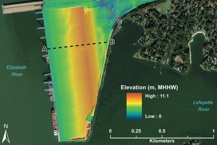
Applying geomorphologic concepts such as Hypsometry and geospatial analyses such as LiDAR provides insights into port vulnerabilities to sea level rise, tidal, pluvial, and combined flood risks.
A collaborative project with the Port of Virginia, Virginia Modeling and Simulation Center (VMASC) and ODU ITS evaluated the exposure and vulnerability of critical infrastructure at a port terminal in Hampton Roads. The project integrated infrastructure and models of storm surges and sea level rise to guide the port’s long-term planning and resilience. The first project at Norfolk International Terminal was presented at the Annual Meeting of the Transportation Review Board (TRB) and published in the Transportation Research Record in 2017. A subsequent study expanded on this, analyzing and comparing 17 different large cargo container terminals on the US East Coast from Savannah, Charleston, Hampton Roads, and New York/New Jersey and was published in Maritime Policy and Management in 2022. A unique element of this project is applying GIS and digital hypsometry, typically used in tectonic geomorphology or coastal marsh studies, to apply LiDAR and inundation modeling to coastal infrastructure.
Innovative Geospatial Techniques for Community Flood Risk Mapping
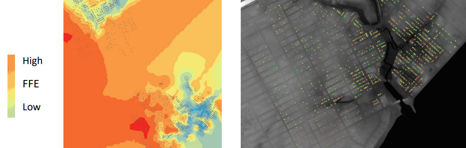
Geostatistics and Machine Learning are applied to field laser surveying and LiDAR in GIS to accurately estimate first floor elevations (FFEs) over large neighborhoods.
A project funded by the FEMA Hazard Mitigation Grant program in collaboration with Virginia Dept. of Emergency Mgt. and VIMS begin in summer-fall 2019. The analysis combines field-based mapping of first floor elevations (FFEs) using laser range-finder/inclinometers and GPS with geostatistical analysis. Combining the field measurements with high-resolution topographic LiDAR through geostatistics will allow efficient estimation of residential building heights and improve the estimation of damage from flooding (i.e., better results with depth-damage curves as calculated by FEMA in programs such as HAZUS.) This effort sparked my outreach project the ODU Blue Line Project to engage students and the public on future sea level rise impacts.
Linking Coastal Water Infrastructure, Public Health, and Sea Level Rise
I recently finished a NOAA Climate Program Office project in collaboration with NC and SC Sea Grant and ECU. We addressed ongoing and future increasing challenges of sea level rise affecting coastal community water infrastructure and specifically the implications for human health in coastal cities and towns. One of the innovative aspects of this project was combining sea level rise with storm surge, tidal flooding, and environmental health and emergency management preparedness and operational response processes. We created tabletop exercises for the public health, emergency management, hospital, utilities, and environmental planning professionals to collaborate and assess future vulnerability (using story maps, a 2030 hurricane disaster scenario, and full-fledged GIS databases for both Charleston, SC, and the Town of Morehead City, NC.) An article on the project was published in the journal Public Works Management & Policy, special issue Climate Change and Infrastructure: The Coming Challenge. Read about it here.
Maritime Geospatial Analysis for Hazards and Sustainable Development
Working in one of the largest natural harbors in the world affords great opportunity for research on marine and maritime GIS. I’ve been publishing a few papers on the sea level rise risk posed to marine terminals of the Port of Virginia and other East Coast Ports. In addition, I’ve begun to leverage that effort in data and spatial analysis to examine impacts to businesses, supply chains, and neighborhoods. One paper compared the relative port vulnerability of Hampton Roads versus the other 3 leading East Coast ports for cargo (NY/NJ, Charleston, and Savannah). This paper on “Sea level rise exposure assessment of U.S. East Coast Cargo container terminals,” is published in Maritime Policy and Management (2021.) In another exploratory project, I’ve mashed up GIS data and historical maps and imagery for Norfolk and Portsmouth to look back at the history of flood impacts (see the story map “Mapping the Maritime Landscape of Hampton Roads.”)
South Atlantic and Florida Salt Marsh Mapping and Vulnerability to Sea Level Rise
Geospatial risk assessment of sea level rise for coastal marshes and forests of the Albemarle Watershed, NC/VA.
A large project supported by the South Atlantic Landscape Conservation Cooperative sought to create consistent spatial datasets of high and low marshes across the southeast USA, depicting fine-scale extents, current distributions, and future vulnerability. The project provides estimates for the entire South Atlantic region and additional detailed information for 3 intensive study areas in NC, SC, and GA. This project is also being continued with support from the Atlantic Coast Joint Venture (ACJV) and the constituent states involved with management of sensitive Black Rail habitat, expanding the mapping of marsh habitats through southern Georgia and Florida into 2019. The project combines Landsat 8 satellite data from USGS and a network of expert avian habitat and coastal management specialists. All data are publicly available for conservation planning and research through the South Atlantic Conservation Planning Atlas. This project was replicated for the entire Florida Peninsula in 2018-20 and resulted in mapping current extents of salt marshes and coastal forests, including mangroves, vulnerable to sea level rise and storm impacts.
NC Coastal Atlas, Coastal WebGIS and Spatial Bibliography
Along with partners at ECU, NOAA, APNEP and NC Division of Coastal Management, I developed a webGIS for the NC coast focusing on bringing diverse geographic information to a broader audience in an accessible platform. Besides a large catalog of streamed and ECU-hosted GIS data, the NC Coastal Atlas also provides a unique spatial bibliography for research on the Albemarle-Pamlico estuary system and wider NC coast. The atlas also supports an interactive clearinghouse of maps for the NOAA NC Sentinel Site Cooperative and the NC Land of Water non-profit organization.
Other ongoing and near-term research projects:
Spatial Analysis and Earth Observation Data Integration for Vulnerable Coastal Environments and Human Settlement.
Applications of Drones/UAVs to Coastal Resilience (development of a customized “Hydrone” Autonomous Surface Vessel/ASV) with ODU Mechanical and Aerospace Engineering.
An exciting new NSF-funded project on “Coastal Squeeze” is the new NSF grant Coupled Mobility of Socio-Environmental Systems in the Coastal Zone with colleagues from Va. Tech and U. Southern Mississippi, just beginning in Fall 2023.